The Snowman Trek is a challenging 24-day trek from Paro to Bumthang valley with stunning views of towering peaks including Mt. Jomulhari, Jichu Drake, Masangang, Mighty Tiger Mountain, and Gangkhar Puensum (highest unclimbed mountain in the world). Trek highlights include a night at Gangkhar Puensum Base Camp and a visit to Dur Tshachu, the country’s most religious hot spring.
From the trek, you can expect the following:
Price Includes
Price Excludes
The flight to Paro offers stunning views of Mt. Everest, Kanchenjunga, and Bhutanese peaks like Jumolhari and Jichu Drakey. After visa formalities, your guide and driver will greet you.
Drive to Paro Valley and visit the following:
– Ta Dzong (National Museum)
– Rinpung Dzong (Paro Dzong)
Evening: Explore Paro Town
Overnight in Paro
Hiking Duration Approx. 5 to 6 hrs roundtrip, Elevation 3120m / 10236ft
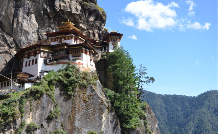
In the morning, take an excursion to Taktsang Monastery, also known as Tiger’s Nest. A chance to get one acclimatized to the tearrains of the Bhutanese Himalayas as well as get blessed by visiting one of the most sacred Buddhist monasteries in Bhutan; The Taktsang Goemba or the Tiger’s Nest Monastery.
Spend the evening re-checking and preparing for the long trek the next day.
Overnight at the hotel in Paro
Distance 22 km/ 7-8 hours, 770 m ascent, 10 m descent, Camp altitude 3,610 m.
After an early breakfast, drive for about 2 hours from Paro to Shana village, passing scenic meadows, paddy fields, and traditional farmhouses. Continue to Gunitsawa village, where your trek permit will be checked at the army post.
The trail then winds through the river valley with gentle ups and downs. As the valley narrows, the path descends to a meadow where you’ll camp for the night. If the weather is nice, you’ll get your first stunning view of Mt. Jumolhari.
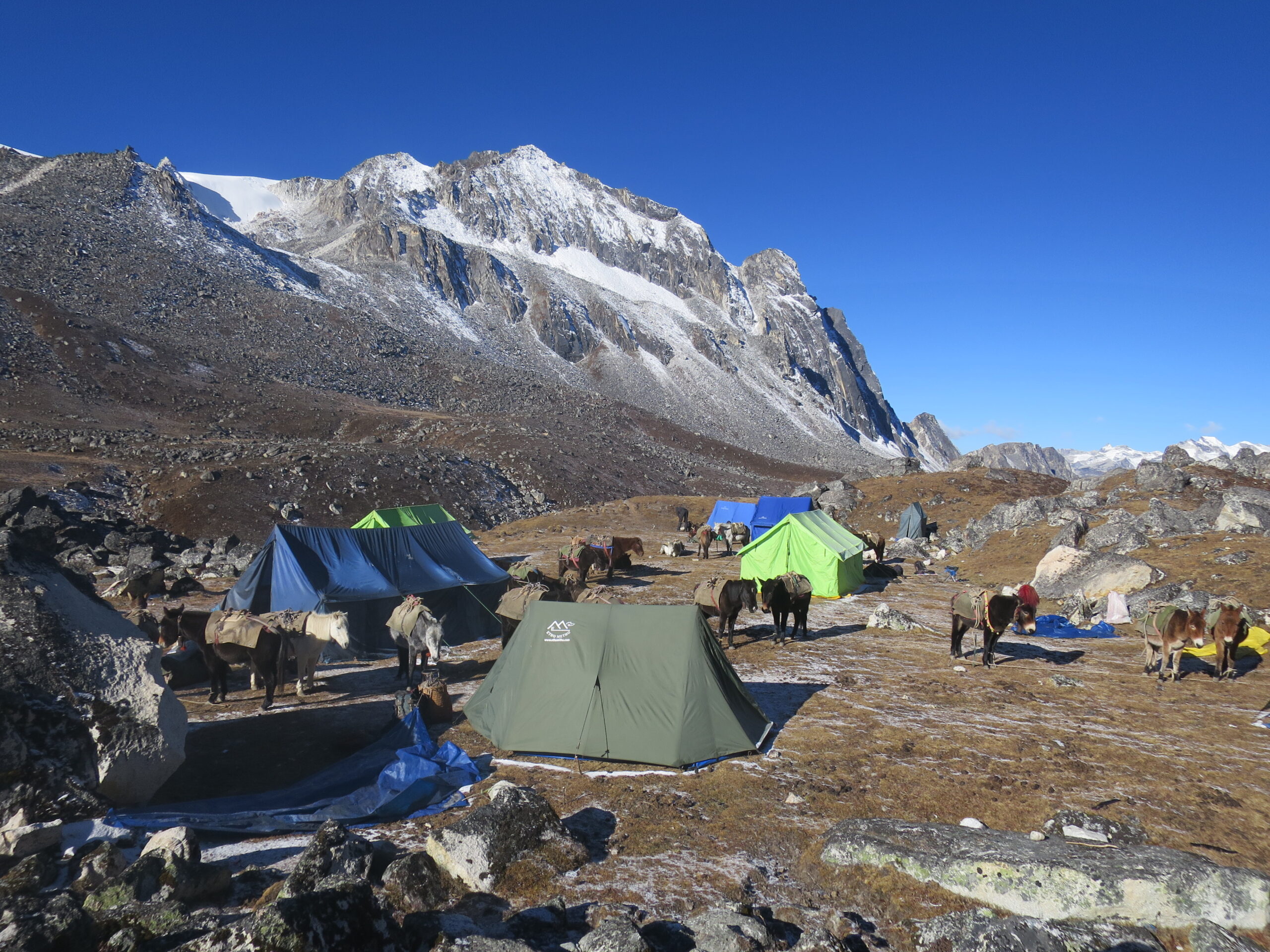
Overnight at campsite (Altitude: 3,610m)
Distance 19 km /7-8 hours, 480 m ascent, Camp altitude 4,080 m.
If you missed Mt. Jomolhari the previous evening, you may catch a clear view this morning. The trek continues up the Paro Chhu valley. Passing Soe, Takethang, and Dangochang villages adds to the experience. At Jangothang, one of the Himalayas’ most beautiful campsites, you’ll again be rewarded with stunning views of Mt. Jomolhari.
Overnight at campsite (Altitude: 4080M)
The rest day at Jangothang offers excellent acclimatization and day hike options with views of lakes and peaks like Jomolhari and Jichu Drake. Short trails lead in three directions—toward Jomolhari in the west, Jichu Drake in the north, and several unclimbed peaks in the east.
Overnight at campsite (Altitude: 4080M)
Distance 18 km/ 7-8 hours, 840 m ascent, 870 m descent, Camp altitude 4,010 m.
This is one of the longest days of the trek. The trail climbs steeply for about 30 minutes, then gradually ascends to Nyilila Pass (4,870m). The trail then descends past yak herder tents made of yak wool. As you enter the Lingshi basin, a scenic U-shaped valley, you may spot Lingshi Dzong and Tserimgang’s glaciers. Camp near a stone hut just before the Dzong.
Overnight at campsite (Altitude: 4010M)
Distance 10 km/ 5-6 hours, 280 m ascent, 410 m descent, Camp altitude 3,880 m.
The trail passes Lingshi Dzong, perched on the hilltop, with an extensive view over the surrounding green hills, winding river and nearby mountains. Today’s route makes for an easy day, walking through villages and yak herders’ camps. After lunch, it is only a short walk to the village of Chebisa, where the camp is located by the side of the stream.
Overnight at the campsite (Altitude: 3880M)
Distance 17 km/ 6-7 hours, 890 m ascent, 540 m descent, Camp altitude 4,220 m.
The day begins with a 2–3 hour ascent behind Chebisa Village through open pastures toward Gobu La Pass (4,410m), where you may see yak herders and blue sheep along the trail. After the pass, descend into a valley, climb briefly, then descend again to Shakshepasa (3,980m). A final short climb brings you to the campsite at Shomuthang, above a tributary of the Nochu River.
Overnight at the campsite (Altitude: 4220M)
Distance 18 km/6-7 hours, 700 m ascent, 760 m descent, Camp altitude: 4,160 m.
The day starts with a climb to Jere La Pass (4,750m), offering views of Kang Bum, Gangchhenta (Great Tiger Mountain), and possibly Jomolhari. Descend into Tsheri Jathang valley, a summer home for takins, then climb briefly to the Robluthang campsite in a rocky meadow.
Overnight at campsite (Altitude: 4160M)
Distance 19 km/ 7-8 hours, 850 m ascent, 870 m descent, Camp altitude 4,140 m.
The trek begins with a 40–60 minute climb, followed by a gradual 1.5-hour ascent through a boulder field, then a steep 1-hour climb to Sinche La (5,005m)—the trek’s highest pass unless continuing beyond Laya. The descent offers views of a glacial lake, terminal moraine, and classic lateral moraines. After crossing the Kango Chhu, you’ll arrive at the Limithang campsite.
Overnight at campsite (Altitude: 4140M)
Distance 11 km/ 5-6 hours, 205 m ascent, 480 m descent, Camp altitude 3,840 m.
A shorter hike follows a trail in and out of a heavily wooded, uninhabited valley. Climbing up out of the forests you will be rewarded with some great views of Mt. Gangchenga and Masang Gang (7165m) mountains. Camp at Laya.
Overnight at campsite (Altitude: 3840M)
Whether coming from Paro or Gasa, it’s recommended to spend a day in Laya to rest and enjoy the stunning views and unique local culture.
Overnight at the campsite (Altitude: 3840M)
Distance 19km/ 7-8 hours, 1,030m ascent, 750m descent, Camp altitude 4,160m.
From Laya we descend to an army camp and continue following the river till the turn off point to Rhoduphu. After lunch the climb continues through rhododendron bushes till you reach the camp at Roduphu just next to the Rhodu Chhu.
Overnight at the campsite (Altitude: 4160M)
Distance 17km/ 5-6 hours, 740m ascent, Camp altitude 4,900m.
After following the river for 30 minutes, you’ll climb to a high valley (4,600m) and then to Tsomo La (4,900m), with stunning views of Lunana, Jomolhari, Jichu Drake, and the Tibetan border. The trail crosses a barren plateau before reaching the Narethang campsite, overlooked by Gangla Karchung (6,395m).
Overnight at the campsite (Altitude: 4900M)
Distance 18km/7-8 hours, 270m ascent, 1,200m descent, Camp altitude 3,970m.
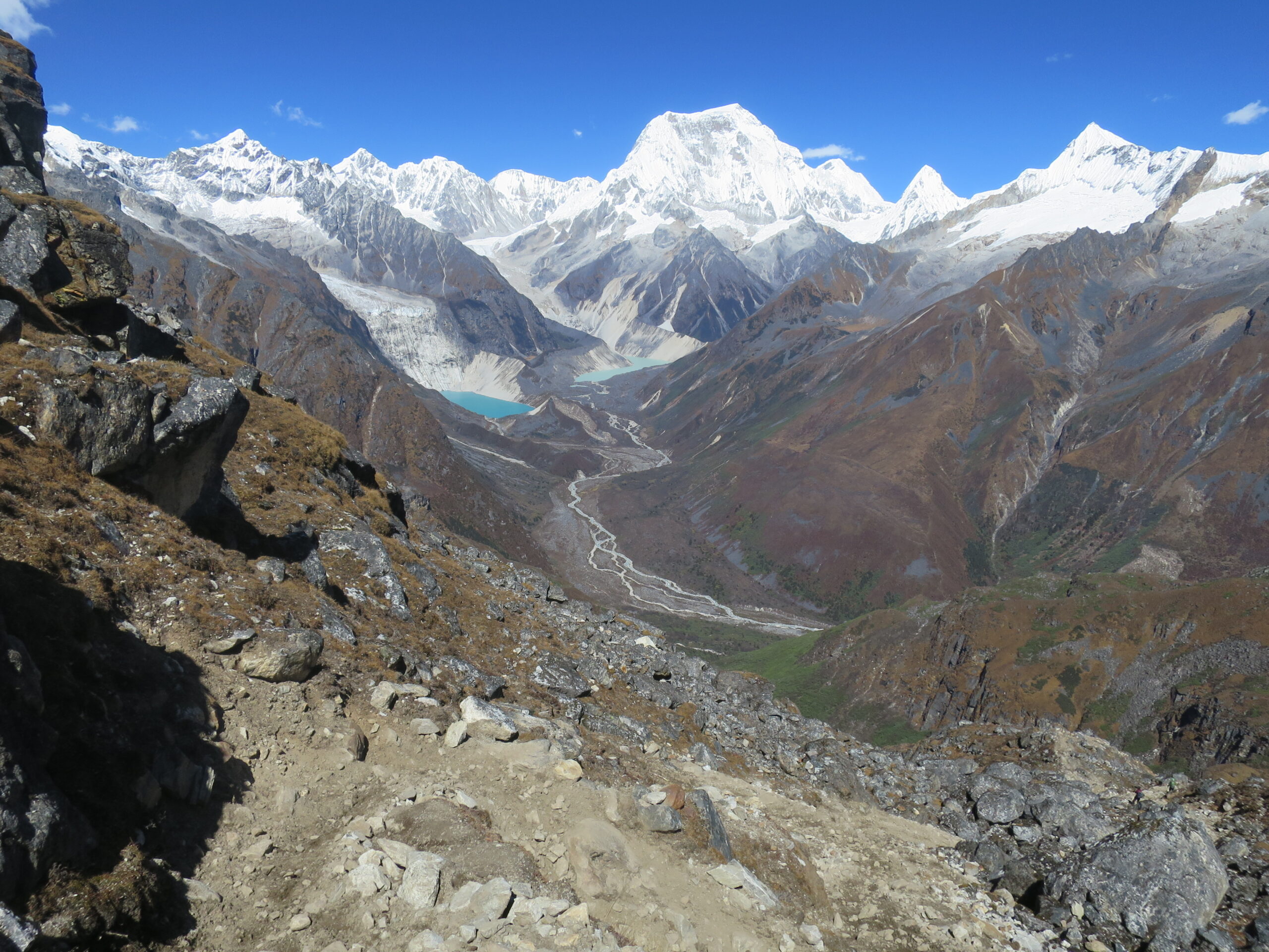
From camp, climb to Gangla Karchung La (5,120m), with stunning views of Jekangphu Gang (7,100m), Tsenda Kang, and Teri Gang (7,300m). Descend along a moraine with spectacular views of a glacier spilling from Teri Kang into a turquoise lake. Continue with a long descent through rhododendron forests to the Tarina valley, where there are several campsites along the Tang Chhu.
Overnight at the campsite (Altitude: 4900M)
Distance 17km/6-7 hours, 270m ascent, 330m descent, Camp altitude 3,910m.
The trail descends through conifer forests along the Pho Chhu, passing waterfalls, then climbs over a ridge and drops into Woche—the first village in the Lunana region.
Overnight at the campsite (Altitude: 3910M)
Distance 19km/ 6-7 hours, 980m ascent, 1,190m descent, Camp altitude 3,700m.
The trail winds through juniper, fir, and rhododendron forests before climbing to Keche La (4,650m) with scenic mountain views. Descend past a village with views of Table Mountain, then follow the river to Lhedi, which has a school, health post, and basic phone service.
Overnight at the campsite (Altitude: 3700M)
Distance 19km/ 7-8 hours, 450m ascent, Camp altitude 4,150m.
On clear days, enjoy stunning views of Table Mountain (7,100m). Around noon, pass Chozo village (4,090m) with its active dzong. Returning to Thanza, admire Table Mountain’s towering 3,000m snow wall. While camping at Thanza is possible, most groups choose nearby Thoencha.
Overnight at the campsite (Altitude: 4150M)
In Thanza walk around and experience some village life or climb up the ridge for fascinating views of lakes and mountains. But as it takes time to arrange new yaks (the yaks from Laya will not go further than Thanza) you might have to spend one day at Thanza anyway.
Overnight at the campsite (Altitude: 4150M)
Distance 19km/ 8-9 hours, Camp altitude 5,120 m.
The trek to Bumthang begins with a ridge climb at 4,500m, offering views of Table Mountain and Thanza valley. After lunch, ascend near a bridge for mountain views, then continue climbing ridges to reach Tshorim campsite.
Overnight at the campsite (Altitude: 5120M)
Distance 16km/ 6-7 hours, Camp altitude 4,970 m.
A trek highlight, the day begins with a short climb to Tshorim Thso lake, offering panoramic views of the Gophu La ranges. A brief final climb reaches Gophu La pass (5,230m), followed by a descent along the ridge with stunning views of Gangkhar Puensum. You may also climb a nearby peak for better views or descend to the base camp by Sha Chhu.
Overnight at the campsite (Altitude: 4970M)
Distance 14km/ 6-7 hours, Camp altitude 4,200 m.
The trail further follows the Sha Chhu and descends gradually to Geshe Woma.
Overnight at the campsite (Altitude: 4970M)
Distance 18km/ 8-9 hours, Camp altitude 4,000 m.
The trail follows Sha Chhu for 2.5 hours before a steep climb to Saka La (4,800m). Visibility is limited, so use the ridge top for guidance. After lunch near a yak herders’ camp, you climb to the pass, then descend past lakes and enjoy a short, scenic ascent amid stunning peaks and small lakes.
Overnight at the campsite (Altitude: 4000M)
Distance 14km/ 5-6 hours, Camp altitude 3,590 m.
A one-hour climb leads to Juli La (4,700m). After the pass, you descend to the riverside through dense rhododendron, juniper and conifer forests. After the bridge a short climb leads to Duer Tsachu. These hot springs, where Guru Padmasambhava is supposed to have taken bath, might be the most stunningly beautiful hot springs of the Himalayas. You might want to spend an extra day at Dur Tsachu.
Overnight at the campsite (Altitude: 3590M)
Distance 18km/ 8-9 hours, Camp altitude 3,850m.
From the hot springs it is a long and steady climb again with great views of mountains in Lunana. You will also come across blue lakes and yak herder huts.
Overnight at the campsite (Altitude: 3850M)
Trekking Duration 18km/ 6hours, 540m Decent, Elevation 2800m/9186 ft
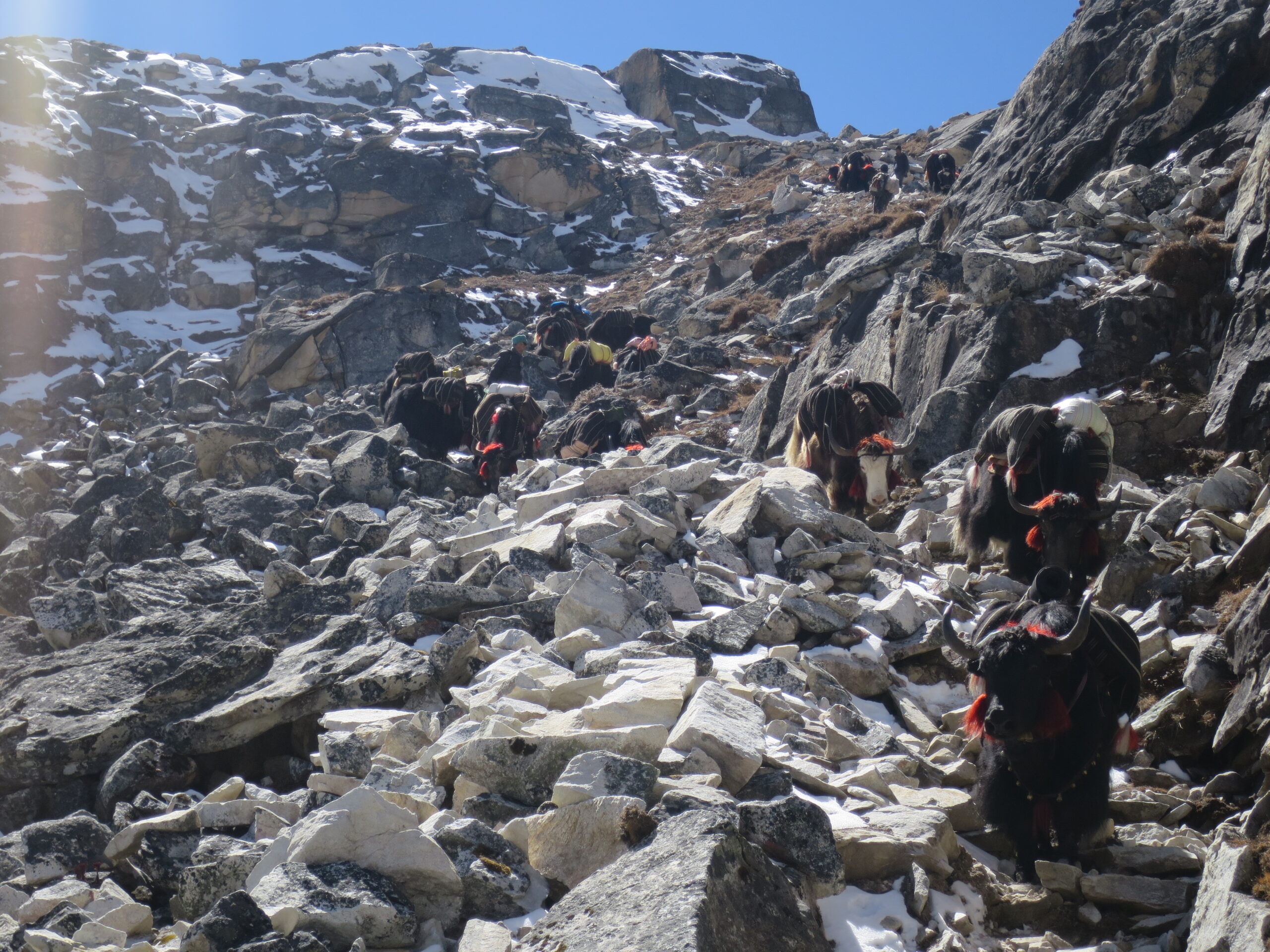
On the final day, porters switch from yaks to horses as you trek to Duer village. After bidding farewell to the crew, you’ll be picked up and driven to a comfortable resort for an overnight stay in Bumthang
Overnight at the hotel in Bumthang
Elevation: 2800m / 9185ft
One can choose to spend the whole day resting or exploring the nearby sights in the valley.
Today we will spend the day with visits to some of the most important Buddhist sites of the Kingdom.
– Jambay Lhakhang
– Kurje Lhakhang
– Tamshing Lhakhang
Overnight at the hotel in Bumthang
Driving Duration 220 km/6-7 hours, Elevation 2900m / 9510ft
Today, we will start early and drive toward Punakha.
Visit the following sites on the way to Punakha:
– Trongsa Dzong
– Chendebji Chorten
The drive continues across Pele La Pass (3,300 m) and after reaching Punakha, visit Chimi Lhakhang.
Overnight at the hotel in Bumthang
Driving Duration 77 km/ 2 hours, Elevation 2350m / 7710ft
Before driving to Thimphu, visit Punakha Dzong.
Then drive to Thimphu and visit the following places:
– Buddha Point
– Centenary Farmers’ Market
Overnight at the hotel in Thimphu
After an early breakfast, drive to Paro. The 30 days Bhutan tour comes to an end with the drive to the airport for the flight to your onward destination.
*******************TOUR ENDS**********************
